
Flood situation near the Yamuna River has become a growing concern for millions of people living in its downstream basin, particularly in Delhi and surrounding regions. Recent heavy rainfall, coupled with massive water discharge from upstream barrages, has pushed the river well above critical danger levels. As communities face displacement, infrastructure strain, and serious health risks, understanding the dynamics of this flood event is vital. This article delves into the causes, immediate impacts, and long-term lessons, offering a comprehensive overview of the ongoing crisis.
Why the Yamuna Is Flooding
Intense Upstream Rainfall
One of the primary drivers of the flood is heavy rainfall in the upstream catchment areas, particularly in Himachal Pradesh and Uttarakhand. These rains feed into the river, swelling its flow down towards the plains.
Massive Discharges from Barrages
Authorities have opened the gates of major barrages:
- The Hathnikund barrage in Haryana saw a release of over 1.78 lakh cusecs, marking the highest discharge this monsoon season.
- Meanwhile, Wazirabad and Okhla barrages are also contributing large volumes into the river.
This sudden influx of water downstream accelerates the risk for flooding, especially where the riverbanks are low-lying.
Reduced Floodplain Capacity
Environmental experts warn that encroachment and construction on the Yamuna floodplain have severely reduced its capacity to absorb excess water. Projects like metro depots, temples, and concrete structures have intruded into the natural floodplain, limiting how much water the river can accommodate during peak flow.
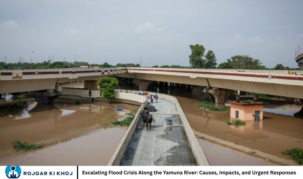
Scale and Scope of the Current Flood Situation
Rising Water Levels in Delhi
- At Delhi’s Old Railway Bridge, the Yamuna level surged to 206.36 meters, a critical mark that triggered widespread alarm.
- The river subsequently crossed 207 meters—a rare event in recent decades.
- Although the water has begun to recede, it remained above the danger mark of 205.33 meters, with the level recorded at 205.56 meters at one point.
Evacuations and Displacement
Authorities have evacuated over 10,000 people from low-lying areas in Delhi. Relief camps and temporary shelters have been established along key routes and in neighborhoods particularly vulnerable to flooding.
Infrastructure Disruption
- Metro access: The approach road to Yamuna Bank metro station became inaccessible due to rising waters.
- Transportation: Heavy traffic snarls emerged in several parts of the city, driven by waterlogging and restricted movement.
- Flood control measures: Authorities closed all 13 regulator drains connected to the Yamuna to prevent backflow into city lowlands.
Underlying Risks and Long-Term Concerns
Erosion of Floodplain Resilience
A deeper issue underscored by experts is the erosion of the Yamuna’s natural floodplain, primarily due to urbanization and illegal construction. This has reduced the river’s natural capacity to manage high waters and led to unconventional flood patterns, where even moderate discharges have triggered high water levels.
Ecological Impacts
The floodplain’s degradation not only raises flood risk but also impacts river ecology. Natural vegetation that once buffered floodwaters is disappearing, replaced by buildings, hard surfaces, and non-native landscaping.
Public Health Threats
With displacement comes increased health risk. Relief camps are vulnerable to waterborne and vector-borne diseases. Stagnant floodwaters, compromised sanitation, and large population movement create conditions conducive to disease spread.
Immediate Actions and Government Response
Emergency Preparedness
Officials have declared a war-footing, mobilizing disaster response teams, flood control units, and municipal workers. Rescue operations are being coordinated by multiple agencies, including the National Disaster Response Force (NDRF).
Preventive Measures
- Sandbags have been deployed at major stormwater drain mouths from Vasudev Ghat to Yamuna Bank.
- Pumping stations are working round the clock: 18 permanent pumping units, 89 mobile pumps, and 32 boats have been deployed for water evacuation.
- The Delhi Jal Board is assisting with managing the flow and monitoring water levels.
Long-Term Strategy Shift
In light of the persistent flood risk, the Delhi Development Authority (DDA) is revising its development strategy for the floodplain:
- Moving away from concrete structures toward green landscapes that can better absorb floodwaters.
- Promoting riverine plantation projects using flood-resilient native species.
- Prioritizing sustainability by designing unpaved paths, solar lighting, and community spaces that can withstand flooding.
Lessons Learned & Policy Recommendations
Restoring and Protecting Floodplain Capacity
Encroachment into the floodplain must be reversed or strictly regulated. Reclaiming and rehabilitating natural floodplain areas can restore the Yamuna’s capacity to absorb floodwaters and reduce peak discharges.
Strengthening Infrastructure with Nature-Based Solutions
- Urban planning should leverage green infrastructure, such as wetlands and bioswales, to mitigate flood risk.
- Multi-tier tree plantation along the riverbanks can serve as both ecological buffer and recreational space.
Improved Water Discharge Management
- Barrage operations (Hathnikund, Wazirabad, Okhla) need adaptive management during monsoon seasons to regulate discharge rates.
- Real-time monitoring of upstream rain forecasts can help in proactive gate opening decisions, reducing downstream shock inflows.
Community Preparedness and Resilience
- Establish early warning systems linked to water-level gauges and meteorological forecasts.
- Strengthen relief infrastructure: more robust, sanitary, and disease-resistant shelters; prepositioned medical kits.
- Conduct regular community training and drills so residents know evacuation routes, safe zones, and health precautions.
Integrated Governance
Flood risk management requires coordination across states (Haryana, Uttarakhand, Uttar Pradesh), central agencies, and local governments:
- Harmonize irrigation and flood control policies across upstream and downstream regions.
- Enforce stringent land-use regulations for the floodplain.
- Promote transboundary collaboration to address climate-induced flood risks.
Frequently Asked Questions
Why is the Yamuna River flooding?
The Yamuna River floods primarily due to heavy rainfall in upstream regions, especially Himachal Pradesh and Uttarakhand, combined with large water releases from upstream barrages. Urban encroachment on floodplains also reduces the river’s capacity to manage high water levels, increasing flood risk downstream.
Which areas are most affected by the Yamuna flood?
The most affected areas include Delhi’s low-lying neighborhoods, parts of Haryana, and areas along the river in Uttar Pradesh. Evacuations are typically focused on vulnerable regions near riverbanks and urban floodplains.
What is the current water level of the Yamuna River in Delhi?
During peak floods, the water level at Delhi’s Old Railway Bridge has crossed 207 meters, surpassing the danger mark of 205.33 meters. Water levels are monitored continuously to inform evacuation and flood management measures.
Are there any health risks associated with Yamuna floods?
Yes. Floodwaters can lead to waterborne diseases, infections, and increased mosquito-borne illnesses. Relief camps may be crowded, so proper sanitation, drinking water safety, and medical care are critical during floods.
Can urban planning prevent Yamuna floods in the future?
Yes. Proper floodplain management, reducing encroachment, adopting green infrastructure, and restoring natural vegetation along the river can significantly reduce flood risks. Long-term planning is key to sustainable flood management.
Conclusion
Flood situation near the Yamuna River is not just a seasonal emergency—it reflects deeper vulnerabilities in urban planning, ecological management, and disaster preparedness. While the immediate response in Delhi has helped mitigate the worst outcomes, long-term resilience will require a holistic rethink: restoring the floodplain, adopting nature-based solutions, and strengthening coordination between agencies.Addressing these challenges is essential. As climate change intensifies and monsoon patterns become more erratic, proactive flood management will be crucial to protect lives, property, and the ecological health of the Yamuna River basin.
